
What does the earth really look like?
Common Flerf meme - with several variations on the theme. Based around the fact that images of the globe earth published at different times by different people and organisations look different.

What is Really Going on
Several debunks have gone over this in detail.
Sly Sparkane Debunk
Flat Earth: Photographs, Composites and CGI looks at the specific meme shown above and details every image. Only 2 a full disk images. The rest are composites.
- Is not actually 1975 but 1972. It is https://nssdc.gsfc.nasa.gov/imgcat/html/object_page/a16_h_118_18885.html Apollo 16 view of the Earth taken with a hand-held Hasselblad camera about an hour and a half after translunar injection on 16 April, 1972
- Is full disk photo. Not a composite - in the sense of joining many images in a mosaic.
It is a Deep Space Climate Observatory (DSCOVR) image generated by combining three separate images to create a photographic-quality image. The camera takes a series of full disk images using different narrowband filters. The red, green and blue channel images are combined to make image 2. So in the sense of colour TV "composite RGB" it is a composite image. - Is https://eoimages.gsfc.nasa.gov/images/imagerecords/7000/7974/Dean_GOES_2007aug20_lrg.jpg
And that was NASA Earth Observatory's - Image of the Day for August 21, 2007. The old link for that was https://earthobservatory.nasa.gov/IOTD/view.php?id=7974 . The new link is https://science.nasa.gov/earth/earth-observatory/hurricane-dean-approaches-yucatan-peninsula-7974/
It is a composite - NASA tells you that it is a composite.This image of Hurricane Dean arriving at the Yucatan is a combination of observations from NASA and NOAA (National Oceanic and Atmospheric Administration) satellites. The clouds, including Hurricane Dean, were observed by a NOAA geostationary weather satellite (GOES-12) at 2:45 p.m. local time in Belize (on the Yucatan Peninsula) on August 20. The land surface is a summertime image from the NASA Blue Marble image collection.
- This is Blue Marble 2000 and was Astronomy Picture of the Day from NASA April 20 2000 https://apod.nasa.gov/apod/ap000420.html
It is a composite. NASA says it is a composite
To create it, researchers at Goddard Space Flight Center's Laboratory for Atmospheres combined data from a Geostationary Operational Environmental Satellite (GOES), the Sea-viewing Wide Field-of-view Sensor (SeaWiFS), and the Polar Orbiting Environmental Satellites (POES) with a USGS elevation model of Earth's topography.
- Is Twin Blue Marbles that was on visibleearth.nasa.gov now available on wayback machine
https://web.archive.org/web/20150823234429/https://visibleearth.nasa.gov/view.php?id=8108. It is a composite. NASA tells you it is a composite.Drawing on data from multiple satellite missions (not all collected at the same time), a team of NASA scientists and graphic artists created layers of global data for everything from the land surface, to polar sea ice, to the light reflected by the chlorophyll in the billions of microscopic plants that grow in the ocean.
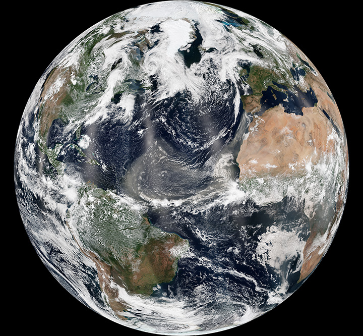
- Is Tracking Dust Across The Atlantic from https://science.nasa.gov/earth/earth-observatory/tracking-dust-across-the-atlantic-81864/
And that page has this https://science.nasa.gov/wp-content/uploads/2025/10/atlanticdust_vir_2013213.jpg which is our image number 6. It is a composite. NASA says it is a compositeThis final view (below) of the dust storm is a composite of VIIRS images from August 1, 2013. The hemispherical projection was created from seven orbits of Suomi NPP.
- is Blue Marble, 2012 https://www.nasa.gov/image-article/blue-marble-2012/
Old URL was www.nasa.gov/multimedia/imagegallery/image_feature_2159.html
It is a composite. NASA tells you that it is a compositeA ‘Blue Marble’ image of the Earth taken from the VIIRS instrument aboard NASA’s most recently launched Earth-observing satellite – Suomi NPP. This composite image uses a number of swaths of the Earth’s surface taken on January 4, 2012.
- This is the Blue Marble 2.0 - Blue Marble 2002 https://science.nasa.gov/resource/blue-marble-2002/ It is a composite. NASA says it is a composite.
In 2002, NASA scientists and visualizers stitched together strips of brand new data, in natural color, collected over four months from the Moderate Resolution Imaging Spectroradiometer, or MODIS, instrument aboard Terra.

Gem panda Debunk
Balls of Blue - a closer look at NASA's Blue Marble and other images of the Earth from space